The four biggest myths about induced demand

This post, by Connor Jones, originally appeared on Urbanist.co. It has been edited to include citations, including the correction of dead links.

Two weeks ago, I laid out the economic argument for induced demand (Jones 2014b): the idea that building more roads does not reduce congestion. It is a simple model that uses concepts from Economics 101 to explain the relationship between road construction and driving behavior.

Even so, this idea, like many associated with new urbanism, challenges the status quo. As such, there’s pushback. To ensure that no falsehoods go unchallenged, I decided to examine the claims in two articles that seek to discredit induced demand as a property. The first is a blog post from the Cato Institute (O’Toole 2014) written in response to a Wired article on the subject (Mann 2014) published last month, and the second is a Weekly Standard (Last 2011) story written three years ago (which is still fresh in urban planning time). Here are the four most prominent false assertions upon which the articles rely.

1. Since roadway capacity is not the only factor affecting driving, induced demand is a flawed model.

This misrepresentation was trotted out by the Cato Institute, which attempted to discredit the academic research of Gilles Duranton of the University of Pennsylvania and Matthew A. Turner of the University of Toronto, who measured the elasticity of demand of vehicle miles traveled (2011).*

On average, driving grew more than twice as fast as lane miles. But in Boston between 1983 and 1993, freeway capacities grew by less than 1 percent, while driving grew by more than 35 percent. In Madison, capacities grew by 35 percent, while driving grew by less than 20 percent. The wide range in differences between urban areas suggests that, not only are Duranton & Turner’s elasticities wrong, their standard errors are far too low. (O’Toole 2014)

Duranton & Turner’s headline finding was that the elasticity of demand in the transportation market is 1, according to roadway data from 1980 to 2000. In other words, holding other factors constant, a 20 percent increase in roadway miles elicits a 20 percent increase in vehicle miles traveled. “We found that there’s this perfect one-to-one relationship,” Turner told Wired (Mann 2014).

Cato fails to account the other variables that affect driving patterns like geography, population growth, and socioeconomic characteristics that Duranton & Turner specifically control for. Simply noting that all cities’ freeway capacities and driving patterns don’t fluctuate in lock step does not show anything.

Duranton & Turner sought to find the relationship between two variables alone and found a striking relationship. We live in the real world, and there are other factors that affect people’s behavior.

2. Cities that have invested in public interstates have seen long-term reduction in congestion.

The Weekly Standard blithely throws out this claim without qualifying it in any way:

The Texas Transportation Institute’s annual Mobility Report, for instance, demonstrates an uncanny correlation between capacity and traffic congestion: Areas that add capacity tend to have lower levels of congestion. (Last 2011)

First off, that’s not what the the authors of the Texas Transportation Institute’s Mobility Report (Schrank, Eisele, and Lomax 2012) found. Instead, they wrote that “additional roadways reduce the rate of congestion increase,” which is a substantively different assertion.

Additionally, their analysis is based on the assumption that roadway growth (supply) and vehicle miles traveled (quantity demanded) are independent of each other. While there are certainly other factors involved, the built environment contributes significantly to people’s behavior. Ignoring this fact is tantamount to building a new road, observing an increase in vehicle miles traveled, then assuming it would have happened anyway. This methodology leads to a skewed result, which isn’t matched by other studies.

The most robust study on the relationship between congestion and roadway growth comes from the Victoria Transport Policy Institute, which found that “Traffic congestion tends to maintain equilibrium. Congestion reaches a point at which it constrains further growth in peak-period trips. If road capacity increases, the number of peak-period trips also increases until congestion again limits further traffic growth.” (Littman 2015)

Plenty of academically-minded people before me have established the economic model. For one, Douglass B. Lee Jr. at the World Bank provides a more rigorous explanation (Lee, n.d.). A meta-analysis of induced demand studies by Robert Cervero in 2003** (Cervero 2003) found strong evidence of the existence of the phenomena, though different researchers have established different elasticity quotients . Recently, Duranton & Turner derived an elasticity of 1 with a very low standard error (2011).

(The Texas Transportation Institute study has several other problems that Tanya Snyder at Streetsblog USA (2013) and Todd Litman at the Transport Policy Institute (2014) can address more thoroughly than I can.)
Continue reading

The street economics of induced demand

From the Novato Narrows to the Richmond Bridge, there’s talking of widening Marin’s highways with nary a thought given to the problems of induced demand, namely that any additional roadway capacity will quickly be used up, negating improvements to traffic speeds.

Guest poster Connor Jones picks things up from here.

There’s a lot of misinformation out there about induced demand (Littman 2015), a widely established city planning model that attempts to explain why cities tend to maintain a steady state of congestion. I’ll go into some more detail on the theory of induced demand later, but I wanted to start with the economic model.

Continue reading.

The case for a comprehensive bike network

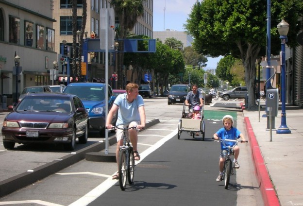
A protected bike lane in Seattle. Photo from downtownseattle.com

A protected bike lane in Seattle Long Beach. Photo from downtownseattle.com

A couple of weeks ago, commenters were largely negative to the idea of protected bicycle lanes on Sir Francis Drake Boulevard for safety reasons and for the reason that the Corte Madera path already existed. But why should we build protected bicycle lanes along high-speed corridors at all? The weight of evidence says it would be of great benefit to cycling in the county generally and to our high-speed corridors specifically.

Network effects

In the Kentfield-Greenbrae corridor, the cycling network is incomplete. The Corte Madera Creek path is a wonderful segment of that network, but it only works for some people. For anyone living north of Sir Francis Drake – yes, there are plenty of flat, bike-friendly streets – that path is useless for getting around the neighborhood. Often, staying off Sir Francis Drake doubles trip times, something no driver would be willing to do.

Continue reading on theGreaterMarin.org

Build something better on South Sir Francis Drake

sfd-segment-1 (1)Tonight, the county will hold a hearing on rebuilding and enhancing Sir Francis Drake Boulevard from the Ross border to Highway 101. (Details: 7pm, College of Marin, Kentfield Campus, Fusselman Hall 120, project site here.) This provides a golden opportunity for Marinites to transform and improve one of Central Marin’s most important streets to better serve people in cars, on bikes, on buses, and on foot.
Continue reading on The Greater Marin’s new site.

Downtown Novato is a better place for a train station

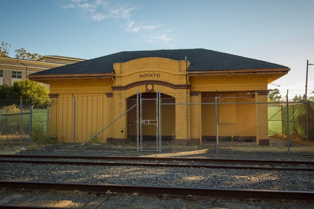
Novato's old station. Image by Jeff on Flickr.

Novato’s old station. Image by Jeff on Flickr.

Novato is reconsidering its decision to push SMART out of downtown Novato and adjacent to Fireman’s Fund. While the calculus seems to be based around the decision by Fireman’s Fund to move, population and jobs numbers today show a downtown location makes much more sense.

Generally speaking, planners define the the catchment area of a train station as a 15 minute walk, or a roughly half-mile radius circle around the station location. Using this metric, the Fireman’s Fund station hosts about 650 jobs, down quite a bit from its peak of 2,400 jobs in 2000. It’s also near 571 people who might want to take the train north or south. Around the downtown station, however, there are still 2,400 jobs and nearly 1,100 people.

Continue reading on theGreaterMarin.org.

The injustice of bundled parking

The other day, we looked at a new apartment building proposed for downtown San Rafael with mindbogglingly expensive parking and tried to determine how the project could be improved. One big way that deserves a second look is allowing people to rent homes and apartments separately.

Continue reading

Checking in DC/Baltimore Railways in 1921

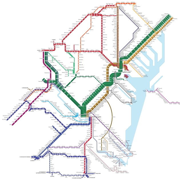
t’s been many weeks since the last update on the mapping projects – it will be weekly from here on in – but there has been considerable progress made on the DC/Baltimore map.

When last we met, I had finished up Baltimore and was on my way to Washington. We’ve made it way, way out of Washington now, with service patterns to Hagerstown, Richmond, and York all laid out. I’ve finally started to chart out river ferry service, which means laying out geography, and that means I can start putting together service to the Eastern Shore and Delaware.

So much progress.

So much progress.

With 950 or so stops to cover, this has been the largest single project I’ve done. Given that it’s nearly August, and the expected delivery was June, this is also taking much longer than I thought it would. And, it’s only getting larger, with additional railway service in the Eastern Shore, where there’s room for it, and a new connection between Winchester, Martinsburg, and Hagerstown.

In the end, this will show nearly all of the railway networks of Maryland and Delaware and about a quarter of Virginia’s, along with slivers of West Virginia and Pennsylvania. I’d like to revisit these states and do state-isolated maps at some point, but not for a long while.

The purpose of maps like this is to show some of the underlying travel patterns that informed our built environment. As well, when activists consider whether to convert an old railway to a trail, or to build a new rail line, they may want to look at old rights-of-way to see whether there’s some latent transit potential there.

This map is available for pre-order in the Map Store, alongside finished prints of the Marin County Interurban in 1939 and the San Francisco Bay Area in 1937.

How to improve the San Rafael apartment proposal

On Wednesday, news broke that San Rafael could soon find itself home to another 162 households, thanks to a proposed redevelopment of the Third Street garage and a couple ancillary buildings. This is the kind of development San Rafael needs more of, and the unique parking situation means it could get even better.

Continue reading on TheGreaterMarin.org

Grady Ranch, two years on

With Marin’s housing crisis in the national spotlight, and the Grady Ranch affordable housing proposal light attracting the journalistic moths, perhaps it is worthwhile to revisit the assumptions made when Grady Ranch was first proposed.

Continue reading…

Will anything ever change?

With the death of Aura Celeste Machado on Point San Pedro Road still fresh in our minds, neighbors and safe streets activists are again calling for traffic calming on the high-speed thoroughfare. But they did the same two years ago when a driver killed Hailey Ratliff on her way home from school in Novato, and there were no substantial changes. Others rallied when a driver killed Olga Rodriguez on Heatherton in San Rafael last year, but nothing changed there, either. Will Celeste’s tragic death be the last straw?

Continue reading…